
.jpg) 1 hour ago
3
1 hour ago
3
Article content
APPENDIX B – Significant Intersection Table
Article content
Collar co-ordinates and orientation are listed in the local Ming Mine grid, which is rotated +35 degrees from NAD83 True North. Significant intersections reported are those above a 1% copper cut-off or 0.5g/t gold, and contain a maximum of 6 metres of internal waste. Please refer to the compliance statements for further details on parameters used in the copper equivalent calculation. All results are approximate true width (TW) unless otherwise noted.
Article content
| Hole Number | Easting | Northing | RL | Azi | Dip | Drilled Length (m) | From (m) | To (m) | Width (m) | Assay | CuEq % | |||
| Cu % | Au g/t | Ag g/t | Zn % | |||||||||||
| MUG25_235 | 1,206.9 | 2,355.8 | -917.0 | 182 | – 68 | 234 | Abandoned due to excessive downhole deviation | |||||||
| MUG25_242 | 1,137.5 | 1,972.0 | -842.4 | 210 | 5 | 15 | Abandoned due to excessive downhole deviation | |||||||
| MUG25_246 | 1,117.0 | 2,190.3 | -894.0 | 215 | -67 | 357 | 314.3 | 318.4 | 4.1 | 5.40 | 2.0 | 13.8 | 1.14 | 7.33 |
| MUG25_247 | 1,255.5 | 2,355.8 | -916.9 | 176 | -70 | 690 | 441.8 | 444.1 | 2.3 | 3.68 | 5.9 | 64.8 | 0.62 | 9.12 |
| 498.0 | 501.5 | 3.5 | 1.33 | 0.5 | 1.8 | 0.07 | 1.75 | |||||||
| 533.2 | 539.0 | 5.9 | 1.52 | 0.2 | 1.7 | 0.15 | 1.71 | |||||||
| 555.0 | 579.0 | 24.0 | 1.00 | 0.1 | 1.0 | 0.01 | 1.06 | |||||||
| 602.5 | 622.0 | 19.6 | 1.40 | 0.1 | 1.9 | 0.01 | 1.45 | |||||||
| MUG25_248 | 1,137.5 | 1,972.0 | -842.4 | 224 | -5 | 45 | Abandoned due to excessive downhole deviation | |||||||
| MUG25_250 | 1,222.1 | 2,255.1 | -906.4 | 162 | -63 | 615 | 505.9 | 511.8 | 5.9 | 1.56 | 0.1 | 1.4 | 0.04 | 1.64 |
| 528.8 | 539.0 | 10.2 | 1.79 | 0.1 | 1.5 | 0.02 | 1.87 | |||||||
| 546.3 | 562.4 | 16.2 | 1.31 | 0.1 | 1.3 | 0.02 | 1.37 | |||||||
| 567.5 | 579.4 | 11.9 | 1.59 | 0.1 | 1.7 | 0.03 | 1.66 | |||||||
| MUG25_251 | 1,117.0 | 2,190.3 | -894.0 | 223 | -75 | 15 | Abandoned due to excessive downhole deviation | |||||||
| MUG25_255 | 1,117.0 | 2,190.3 | -894.0 | 223 | -57 | 357 | 319.8 | 330.3 | 10.5 | 3.05 | 1.8 | 16.5 | 1.50 | 4.86 |
| MUG25_256 | 1,255.5 | 2,355.8 | -916.9 | 172 | -76 | 45 | Abandoned due to excessive downhole deviation | |||||||
| MUG25_257 | 1,137.5 | 1,972.0 | -842.4 | 226 | -9 | 363 | 285.1 | 287.4 | 2.3 (1.6m TW) | 3.20 | 4.9 | 31.3 | 1.36 | 7.68 |
| 291.4 | 296.7 | 5.3 (4.8m TW) | 0.80 | 1.6 | 6.2 | 0.24 | 2.17 | |||||||
| MUG25_258 | 1,255.5 | 2,355.8 | -916.9 | 172 | -76 | 696 | 517.0 | 529.0 | 12.0 | 1.33 | 0.2 | 1.3 | 0.10 | 1.51 |
| 557.3 | 566.0 | 8.7 | 1.82 | 0.2 | 1.9 | 0.03 | 2.04 | |||||||
| 598.0 | 603.2 | 5.2 | 1.39 | 0.1 | 1.2 | 0.01 | 1.46 | |||||||
| 611.0 | 614.0 | 3.0 | 1.20 | 0.0 | 0.9 | 0.01 | 1.24 | |||||||
| 628.8 | 660.0 | 31.3 | 1.97 | 0.1 | 2.4 | 0.01 | 2.07 | |||||||
| MUG25_260 | 1,117.0 | 2,190.3 | -894.0 | 227 | -64 | 381 | 322.8 | 332.5 | 9.8 | 5.04 | 1.8 | 12.9 | 1.34 | 6.80 |
| MUG25_261 | 1,056.9 | 2,298.9 | -899.7 | 185 | -79 | 450 | 400.3 | 403.4 | 3.1 | 7.99 | 2.6 | 19.0 | 1.65 | 10.55 |
| MUG25_262 | 1,137.5 | 1,972.0 | -842.4 | 229 | -15 | 375 | 262.9 | 269.2 | 6.3 (4.4m TW) | 1.72 | 1.4 | 11.7 | 0.83 | 3.08 |
| MUG25_263 | 1,117.0 | 2,190.3 | -894.0 | 235 | -70 | 414 | 342.1 | 345.0 | 2.9 | 1.25 | 0.5 | 3.3 | 0.60 | 1.78 |
| MUG25_264 | 1,137.5 | 1,972.0 | -842.4 | 234 | -22 | 375 | 254.8 | 261.6 | 6.8 (4.8m TW) | 2.49 | 2.5 | 28.7 | 2.24 | 5.12 |
| MUG25_265 | 1,117.0 | 2,190.3 | -894.0 | 227 | -51 | 360 | 326.5 | 330.3 | 3.8 | 2.43 | 1.2 | 13.9 | 1.98 | 3.82 |
| MUG25_266 | 1,185.8 | 2,352.2 | -916.1 | 175 | -74 | 641 | 457.0 | 459.9 | 2.9 | 1.81 | 0.9 | 10.3 | 3.56 | 3.19 |
| 476.7 | 478.7 | 2.0 | 1.91 | 0.3 | 3.9 | 0.05 | 2.21 | |||||||
| 484.6 | 486.8 | 2.2 | 1.66 | 0.1 | 2.6 | 0.09 | 1.77 | |||||||
| 512.0 | 529.8 | 17.8 | 1.86 | 0.4 | 2.6 | 0.02 | 2.18 | |||||||
| 536.3 | 573.0 | 36.8 | 1.98 | 0.1 | 1.8 | 0.11 | 2.08 | |||||||
| MUG25_267 | 1,056.9 | 2,298.9 | -899.7 | 193 | -74 | 429 | 390.1 | 399.4 | 9.3 | 5.10 | 1.6 | 20.3 | 2.94 | 7.00 |
| MUG25_268 | 1,096.0 | 2,286.3 | -899.1 | 162 | -72 | 48 | Abandoned due to excessive downhole deviation | |||||||
| MUG25_269 | 1,255.5 | 2,355.8 | -916.9 | 187 | -75 | 210 | Abandoned due to excessive downhole deviation | |||||||
| MUG25_270 | 1,117.0 | 2,190.3 | -894.0 | 233 | -57 | 375 | 329.4 | 338.8 | 9.4 | 2.66 | 1.4 | 12.5 | 2.03 | 4.26 |
| 340.5 | 348.0 | 7.5 | 0.03 | 1.1 | 7.4 | 0.56 | 1.08 | |||||||
| MUG25_271 | 1,096.0 | 2,286.3 | -899.1 | 162 | -72 | 147 | Abandoned due to excessive downhole deviation | |||||||
| MUG25_272 | 1,137.5 | 1,972.0 | -842.4 | 223 | 7 | 540 | 465.2 | 489.8 | 24.7 (16.0m TW) | 1.39 | 2.6 | 20.8 | 0.38 | 3.74 |
| 501.4 | 504.0 | 2.6 (1.7m TW) | 4.38 | 9.9 | 38.3 | 1.80 | 13.14 | |||||||
| MUG25_273 | 1,056.9 | 2,298.9 | -899.7 | 197 | -68 | 408 | 375.9 | 378.2 | 2.3 | 4.04 | 1.4 | 14.9 | 0.56 | 5.41 |
| 391.1 | 396.9 | 5.8 | 1.95 | 0.8 | 4.2 | 0.17 | 2.66 | |||||||
| MUG25_274 | 1,255.5 | 2,355.8 | -916.9 | 187 | -75 | 15 | Abandoned due to excessive downhole deviation | |||||||
| MUG25_275 | 1,096.0 | 2,286.3 | -899.1 | 162 | -72 | 143 | Abandoned due to excessive downhole deviation | |||||||
| MUG25_276 | 1,255.5 | 2,355.8 | -916.9 | 187 | -75 | 711 | 464.3 | 469.0 | 4.8 | 0.87 | 1.5 | 13.6 | 0.90 | 2.38 |
| 473.0 | 479.0 | 6.0 | 3.53 | 2.1 | 28.9 | 0.58 | 5.58 | |||||||
| 543.9 | 547.0 | 3.1 | 1.31 | 0.1 | 1.1 | 0.16 | 1.42 | |||||||
| 567.0 | 599.0 | 32.0 | 1.41 | 0.1 | 1.5 | 0.18 | 1.50 | |||||||
| 607.0 | 613.0 | 6.0 | 1.62 | 0.1 | 2.5 | 0.15 | 1.74 | |||||||
| MUG25_277 | 1,117.0 | 2,190.3 | -894.0 | 230 | -64 | 375 | 329.5 | 341.3 | 11.8 | 2.32 | 1.2 | 11.2 | 1.56 | 3.62 |
| MUG25_278 | 1,185.8 | 2,352.2 | -916.1 | 175 | -78 | 642 | 460.8 | 468.2 | 7.4 | 2.14 | 1.2 | 8.6 | 0.82 | 3.33 |
| 484.1 | 519.8 | 35.7 | 3.07 | 0.2 | 3.2 | 0.04 | 3.27 | |||||||
| 531.1 | 548.7 | 17.6 | 1.64 | 0.1 | 1.2 | 0.04 | 1.74 | |||||||
| MUG25_279 | 1,096.0 | 2,286.3 | -899.1 | 162 | -72 | 471 | 384.2 | 401.9 | 17.8 | 5.40 | 1.3 | 15.8 | 0.36 | 6.69 |
| 413.0 | 415.0 | 2.0 | 1.85 | 0.1 | 1.7 | 0.06 | 1.99 | |||||||
| 423.1 | 426.0 | 2.9 | 1.36 | 0.1 | 1.1 | 0.18 | 1.49 | |||||||
| MUG25_280 | 1,056.9 | 2,298.9 | -899.7 | 205 | -64 | 411 | 383.5 | 387.7 | 4.2 | 2.71 | 1.1 | 13.4 | 2.96 | 4.20 |
| MUG25_281 | 1,255.5 | 2,355.8 | -916.9 | 190 | -83 | 753 | 509.2 | 518.4 | 9.2 | 1.79 | 4.9 | 21.5 | 0.49 | 6.09 |
| 580.5 | 588.5 | 8.0 | 2.09 | 0.2 | 1.7 | 0.11 | 2.33 | |||||||
| 595.0 | 598.0 | 3.0 | 1.27 | 0.1 | 1.1 | 0.09 | 1.38 | |||||||
| 612.8 | 642.9 | 30.1 | 1.92 | 0.1 | 2.0 | 0.32 | 2.06 | |||||||
| 725.4 | 728.4 | 3.0 | 1.56 | 0.3 | 4.6 | 0.04 | 1.81 | |||||||
| MUG25_282 | 1,185.8 | 2,352.2 | -916.1 | 190 | -78 | 15 | Abandoned due to excessive downhole deviation | |||||||
| MUG25_283 | 1,117.0 | 2,190.3 | -894.0 | 236 | -43 | 438 | 365.3 | 369.2 | 3.9 | 1.39 | 1.2 | 16.8 | 0.67 | 2.62 |
| MUG25_284 | 1,056.9 | 2,298.9 | -899.7 | 206 | -78 | 36 | Abandoned due to excessive downhole deviation | |||||||
| MUG25_285 | 1,185.8 | 2,352.2 | -916.1 | 190 | -78 | 575 | 461.1 | 506.4 | 45.3 | 2.61 | 0.4 | 4.3 | 0.29 | 3.01 |
| MUG26_001 | 1,137.5 | 1,972.0 | -842.4 | 232 | 8 | 547 | 526.8 | 528.8 | 2.0 (1.2m TW) | 1.17 | 0.1 | 1.2 | 0.06 | 1.26 |
| MUG26_002 | 964.7 | 2,163.4 | -877.5 | 192 | -20 | 357 | 308.2 | 315.2 | 7.0 (5.6m TW) | 4.62 | 2.7 | 27.3 | 0.40 | 7.09 |
| MUG26_003 | 1,056.9 | 2,298.9 | -899.7 | 206 | -78 | 432 | 404.0 | 416.8 | 12.8 | 3.02 | 2.0 | 12.6 | 3.33 | 5.28 |
| MUG26_004 | 1,096.0 | 2,286.3 | -899.1 | 159 | -73 | 72 | Abandoned due to excessive downhole deviation | |||||||
| MUG26_005 | 1,255.5 | 2,355.8 | -916.9 | 179 | -73 | 690 | 452.9 | 457.3 | 4.4 | 0.79 | 2.6 | 26.8 | 0.59 | 3.23 |
| 513.3 | 519.0 | 5.7 | 1.57 | 0.2 | 2.7 | 0.13 | 1.79 | |||||||
| 546.5 | 550.0 | 3.5 | 1.55 | 0.2 | 1.9 | 0.04 | 1.70 | |||||||
| 570.1 | 582.0 | 12.0 | 1.27 | 0.1 | 1.1 | 0.01 | 1.33 | |||||||
| 595.0 | 602.8 | 7.8 | 1.12 | 0.0 | 1.1 | 0.01 | 1.17 | |||||||
| 607.2 | 634.0 | 26.8 | 1.35 | 0.1 | 1.7 | 0.01 | 1.42 | |||||||
| MUG26_006 | 1,096.0 | 2,286.3 | -899.1 | 155 | -73 | 15 | Abandoned due to excessive downhole deviation | |||||||
| MUG26_007 | 1,056.9 | 2,298.9 | -899.7 | 209 | -72 | 9 | Abandoned due to excessive downhole deviation | |||||||
| MUG26_008 | 1,185.8 | 2,352.2 | -916.1 | 191 | -89 | 620 | 484.2 | 489.9 | 5.8 | 2.90 | 0.4 | 6.0 | 0.25 | 3.30 |
| 513.3 | 538.5 | 25.3 | 3.54 | 0.3 | 3.8 | 0.06 | 3.79 | |||||||
| 561.1 | 568.0 | 6.9 | 1.88 | 0.1 | 1.5 | 0.06 | 1.98 | |||||||
| MUG26_009 | 1,056.9 | 2,298.9 | -899.7 | 209 | -72 | 423 | No Significant Assays | |||||||
| MUG26_010 | 1,096.0 | 2,286.3 | -899.1 | 155 | -73 | 6 | Abandoned due to excessive downhole deviation | |||||||
| MUG26_011 | 1,096.0 | 2,286.3 | -899.1 | 155 | -73 | 22 | Abandoned due to excessive downhole deviation | |||||||
| MUG26_012 | 964.7 | 2,163.4 | -877.5 | 191 | -38 | 330 | No Significant Assays | |||||||
| MUG26_013 | 1,096.0 | 2,286.3 | -899.1 | 155 | -73 | 453 | 375.0 | 395.7 | 20.7 | 5.90 | 1.9 | 14.1 | 0.74 | 7.71 |
| 411.0 | 416.8 | 5.8 | 3.39 | 0.2 | 3.8 | 0.22 | 3.63 | |||||||
| MUG26_014 | 1,137.5 | 1,972.0 | -842.4 | 230 | -4 | 429 | No Significant Assays | |||||||
| MUG26_015 | 1,056.9 | 2,298.9 | -899.7 | 213 | -67 | 414 | 389.5 | 400.0 | 10.6 | 3.72 | 1.7 | 20.0 | 3.57 | 5.82 |
| MUG26_016 | 964.7 | 2,163.4 | -877.5 | 200 | -36 | 351 | No Significant Assays | |||||||
| MUG26_017 | 1,255.5 | 2,355.8 | -916.9 | 190 | -87 | 111 | Abandoned due to excessive downhole deviation | |||||||
| MUG26_018 | 962.6 | 2,163.8 | -877.0 | 209 | -36 | 348 | No Significant Assays | |||||||
| MUG26_019 | 1,185.8 | 2,352.2 | -916.1 | 197 | -75 | 51 | Abandoned due to excessive downhole deviation | |||||||
| MUG26_020 | 1,056.9 | 2,298.9 | -899.7 | 222 | -75 | 459 | No Significant Assays | |||||||
| MUG26_021 | 1,255.5 | 2,355.8 | -916.9 | 190 | -87 | 21 | Abandoned due to excessive downhole deviation | |||||||
| MUG26_022 | 1,255.5 | 2,355.8 | -916.9 | 190 | -87 | 657 | 506.2 | 510.1 | 3.9 | 2.51 | 4.3 | 65.1 | 0.86 | 6.72 |
| MUG26_022 | 550.3 | 553.1 | 2.8 | 2.19 | 0.2 | 2.4 | 0.05 | 2.39 | ||||||
| 556.8 | 559.4 | 2.6 | 1.12 | 0.0 | 1.2 | 0.02 | 1.17 | |||||||
| 563.3 | 575.9 | 12.6 | 1.55 | 0.4 | 2.1 | 0.02 | 1.88 | |||||||
| 588.6 | 608.0 | 19.4 | 1.84 | 0.1 | 1.8 | 0.14 | 1.95 | |||||||
| 615.5 | 618.8 | 3.3 | 1.10 | 0.0 | 1.0 | 0.06 | 1.15 | |||||||
| MUG26_023 | 964.7 | 2,163.4 | -877.5 | 185 | -49 | 339 | 273.2 | 281.7 | 8.6 (6.4m TW) | 1.80 | 2.0 | 20.7 | 2.97 | 4.05 |
| MUG26_024 | 1,096.0 | 2,286.3 | -899.1 | 166 | -78 | 16 | Abandoned due to excessive downhole deviation | |||||||
| MUG26_025 | 1,096.0 | 2,286.3 | -899.1 | 166 | -78 | 9 | Abandoned due to excessive downhole deviation | |||||||
| MUG26_026 | 1,096.0 | 2,286.3 | -899.1 | 166 | -78 | 25 | Abandoned due to excessive downhole deviation | |||||||
| MUG26_027 | 1,185.8 | 2,352.2 | -916.1 | 197 | -75 | 12 | Abandoned due to excessive downhole deviation | |||||||
| MUG26_028 | 1,185.8 | 2,352.2 | -916.1 | 197 | -75 | 531 | 436.9 | 471.3 | 34.4 | 3.81 | 1.2 | 11.0 | 0.56 | 4.98 |
| Including | 436.9 | 451.2 | 14.3 | 5.16 | 2.5 | 21.4 | 1.21 | 7.62 | ||||||
| MUG26_029 | 1,096.0 | 2,286.3 | -899.1 | 166 | -78 | 441 | 377.0 | 390.6 | 13.6 | 5.72 | 1.1 | 15.4 | 0.40 | 6.83 |
| MUG26_030 | 964.7 | 2,163.4 | -877.5 | 199 | -3 | 18 | Abandoned due to excessive downhole deviation | |||||||
| MUG26_031 | 1,056.9 | 2,298.9 | -899.7 | 205 | -58 | 408 | 373.5 | 382.7 | 9.2 | 2.18 | 1.0 | 14.6 | 2.75 | 3.56 |
| MUG26_032 | 1,137.5 | 1,972.0 | -842.4 | 235 | -7 | 414 | No Significant Assays | |||||||
| MUG26_033 | 964.7 | 2,163.4 | -877.5 | 199 | -3 | 426 | No Significant Assays | |||||||
| MUG26_034 | 1,096.0 | 2,286.3 | -899.1 | 171 | -84 | 444 | No Significant Assays | |||||||
| MUG26_035 | 1,137.5 | 1,972.0 | -842.4 | 212 | 2 | 75 | Abandoned due to excessive downhole deviation | |||||||
| MUG26_036 | 1,185.8 | 2,352.2 | -916.1 | 187 | -66 | 555 | 425.9 | 476.1 | 50.2 | 3.50 | 0.4 | 5.1 | 0.73 | 3.97 |
| Including | 425.9 | 437.7 | 11.8 | 2.25 | 0.6 | 7.4 | 2.87 | 3.22 | ||||||
| MUG26_036 | Including | 443.7 | 476.1 | 32.4 | 4.52 | 0.1 | 1.6 | 0.02 | 4.66 | |||||
| MUG26_037 | 964.7 | 2,163.4 | -877.5 | 205 | -2 | 441 | No Significant Assays | |||||||
| MUG26_038 | 1,062.6 | 2,299.0 | -899.2 | 194 | -62 | 423 | 369.7 | 388.3 | 18.6 | 4.48 | 1.7 | 17.2 | 0.80 | 6.13 |
| MUG26_039 | 1,137.5 | 1,972.0 | -842.4 | 212 | 4 | 420 | 340.9 | 347.0 | 6.1 (4.3m TW) | 4.40 | 3.7 | 27.9 | 1.33 | 7.91 |
| MUG26_040 | 1,255.5 | 2,355.8 | -916.9 | 40 | -87 | 780 | 571.0 | 573.0 | 2.0 | 3.21 | 1.9 | 7.7 | 0.20 | 4.89 |
| 604.0 | 612.0 | 8.0 | 2.06 | 0.3 | 2.3 | 0.10 | 2.34 | |||||||
| 625.0 | 628.0 | 3.0 | 4.04 | 0.3 | 4.3 | 0.02 | 4.35 | |||||||
| MUG26_041 | 1,137.5 | 1,972.0 | -842.4 | 221 | 5 | 474 | No Significant Assays | |||||||
| MUG26_042 | 1,062.6 | 2,299.0 | -899.2 | 206 | -29 | 477 | 387.3 | 398.8 | 11.6 (10.4m TW) | 2.94 | 2.5 | 19.1 | 0.78 | 5.23 |
| MUG26_043 | 964.7 | 2,163.4 | -877.5 | 210 | -1 | 477 | 422.8 | 425.3 | 2.4 (1.8m TW) | 0.38 | 2.2 | 13.7 | 0.06 | 2.29 |
| MUG26_044 | 1,185.8 | 2,352.2 | -916.1 | 191 | -81 | 657 | 468.2 | 494.1 | 25.9 | 5.48 | 1.0 | 8.4 | 0.21 | 6.43 |
| MUG26_045 | 1,174.0 | 2,400.0 | -916.1 | 198 | -68 | 507 | 453.4 | 457.0 | 3.6 | 1.96 | 0.6 | 5.8 | 0.33 | 2.54 |
| MUG26_046 | 1,062.6 | 2,299.0 | -899.2 | 209 | -38 | 438 | 391.0 | 395.5 | 4.5 | 3.05 | 3.1 | 30.9 | 1.61 | 6.09 |
| MUG26_047 | 964.7 | 2,163.4 | -877.5 | 196 | -12 | 15 | Abandoned due to excessive downhole deviation | |||||||
| MUG26_048 | 1,137.5 | 1,972.0 | -842.4 | 212 | 1 | 45 | Abandoned due to excessive downhole deviation | |||||||
| MUG26_049 | 1,185.8 | 2,352.2 | -916.1 | 198 | -70 | 15 | Abandoned due to excessive downhole deviation | |||||||
| MUG26_050 | 1,174.0 | 2,400.0 | -916.1 | 210 | -65 | 489 | No Significant Assays | |||||||
| MUG26_051 | 964.7 | 2,163.4 | -877.5 | 196 | -12 | 411 | No Significant Assays | |||||||
| MUG26_052 | 1,185.8 | 2,352.2 | -916.1 | 198 | -70 | 15 | Abandoned due to excessive downhole deviation | |||||||
| MUG26_053 | 1,185.8 | 2,352.2 | -916.1 | 198 | -70 | 534 | 413.1 | 455.1 | 42.0 | 4.74 | 1.4 | 10.0 | 0.84 | 6.13 |
| Including | 421.6 | 431.4 | 9.8 | 12.68 | 4.0 | 27.8 | 1.60 | 16.46 | ||||||
| MUG26_054 | 1,255.5 | 2,355.8 | -916.9 | 202 | -51 | 495 | 404.7 | 456.1 | 51.5 | 3.99 | 0.9 | 9.0 | 0.87 | 4.91 |
| Including | 415.0 | 432.0 | 17.0 | 7.48 | 1.7 | 17.4 | 0.72 | 9.09 | ||||||
| MUG26_055 | 964.9 | 2,163.3 | -877.5 | 198 | -49 | 15 | Abandoned due to excessive downhole deviation | |||||||
Article content
Article content
Article content
APPENDIX C – JORC CODE, 2012 EDITION
Article content
Table 1
Article content
Section 1 – Sampling Techniques and Data (Criteria in this section apply to all succeeding sections)
Article content
| Criteria | JORC Code explanation | Commentary |
| Sampling techniques |
|
The following is a summary of the core sampling procedure:
|
| Drilling techniques |
|
|
| Drill sample recovery |
|
|
| Logging |
| The following steps are completed during the core logging procedure:
|
| Sub-sampling techniques and sample preparation |
|
|
| Quality of assay data and laboratory tests |
|
|
| Verification of sampling and assaying |
|
|
| Location of data points |
|
|
| Data spacing and distribution |
|
|
| Orientation of data in relation to geological structure |
|
|
| Sample security |
|
|
| Audits or reviews |
|
|
Article content
Article content
Section 2 – Reporting of Exploration Results (Criteria in this section apply to all succeeding sections)
Article content
| Criteria | JORC Code explanation | Commentary |
| Mineral tenement and land tenure status |
|
|
| Exploration done by other parties |
|
|
| Geology |
|
|
| Drill hole Information |
|
|
| Data aggregation methods |
|
The competent person determined to include of the 0.75m @ 0.08% Cu in the intersection because in a mining scenario, it is unlikely that this internal dilution could be separated.
|
| Relationship between mineralisation widths and intercept lengths |
|
|
| Diagrams |
|
|
| Balanced reporting |
|
|
| Other substantive exploration data |
|
|
| Further work |
|
|
Article content
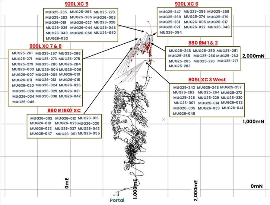
Plan view of drilling in this announcement
Article content
Article content
Figures accompanying this announcement are available at:
Article content
Article content
Article content
Article content
Article content
Article content
Article content
Article content

Article content
Article content
 English (US)