
.jpg) 1 hour ago
2
1 hour ago
2
Article content
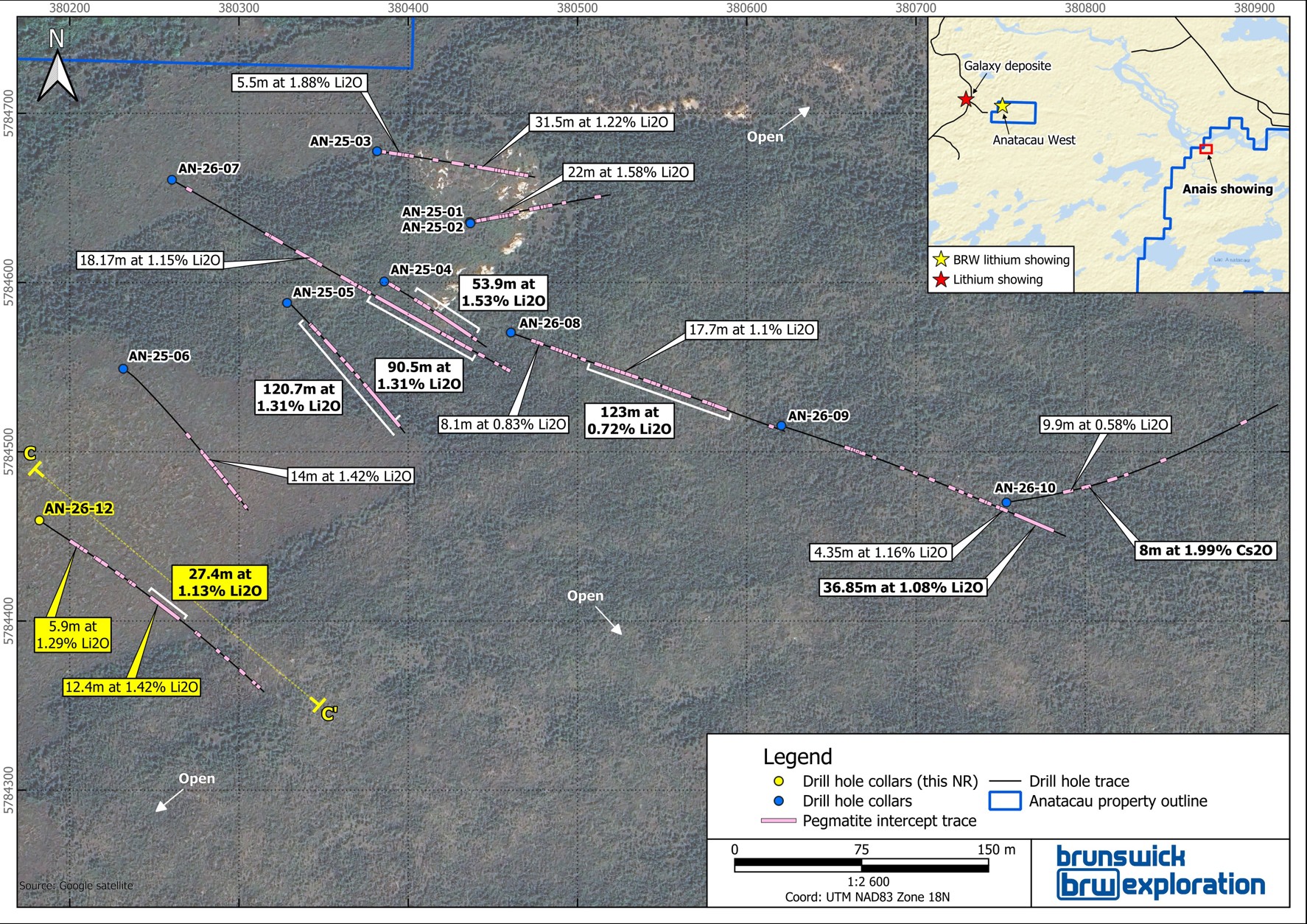
The Anais Main dyke is interpreted to be gently folded, oriented North-South to Northeast-Southwest, dipping at 85° to the West. To date, this dyke measures 350 meters along strike to a vertical depth of 200 meters and a width of approximately 40 meters.
Article content
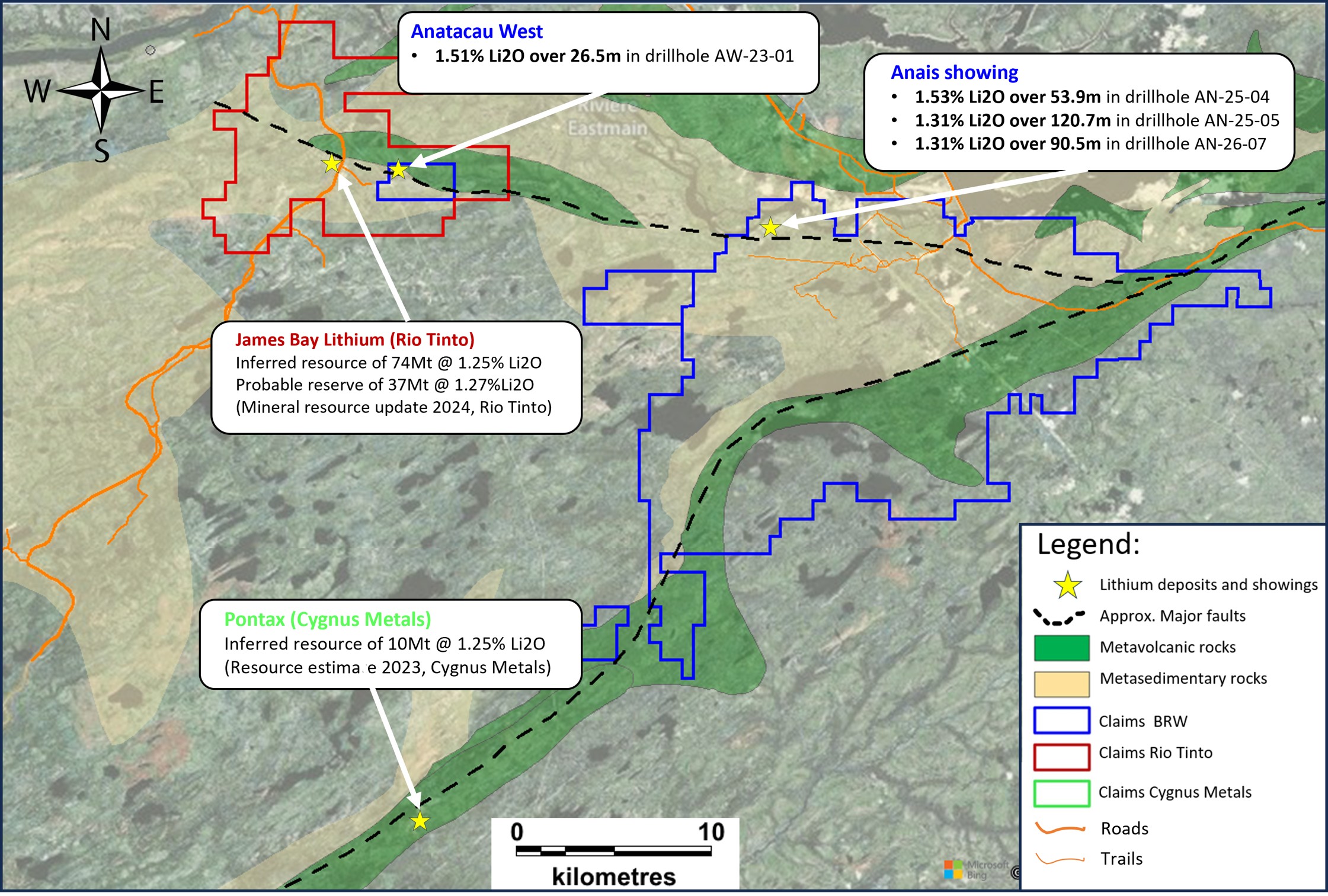
The surrounding several mineralized dykes are interpreted to be stacked, subparallel, and steeply dipping toward the west, and are all hosted within the same structural corridor that hosts Rio Tinto’s Galaxy Project (54.3 Mt M&I at 1.30% Li₂O and 55.9 Mt Inferred at 1.29% Li₂O, see Note) and BRW’s Anatacau West Project, which is immediately contiguous to Rio Tinto’s claim package and located approximately 20 kilometers west of the Anais Main dyke (Figure 3).
Article content
Discussion of Results
Article content
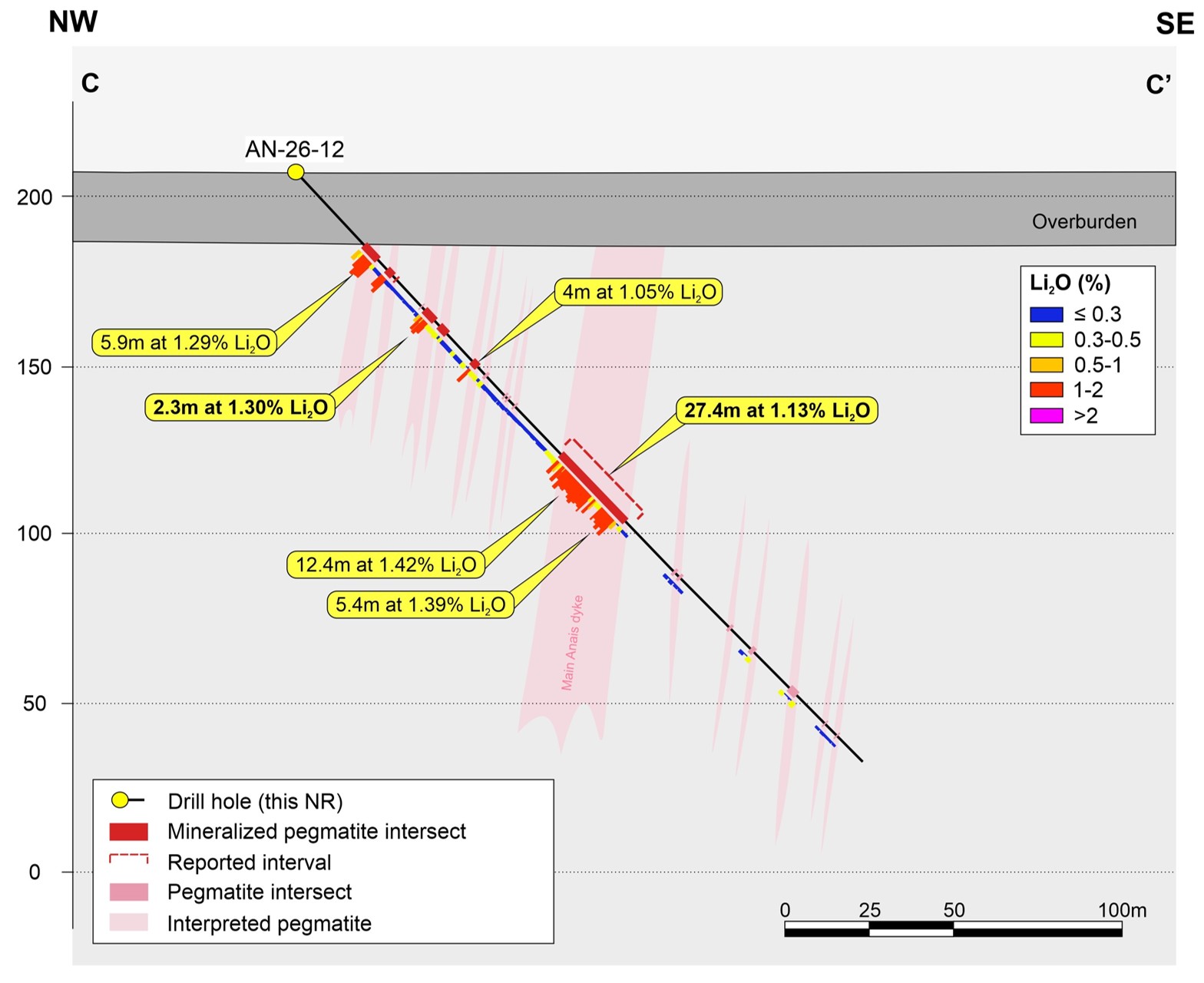
Hole AN-26-12 collared into a mineralized pegmatite and intersected six well-mineralized, stacked pegmatite dykes, including a continuous interval of lithium mineralization of 27.4 meters grading 1.13% Li₂O at a very shallow vertical depth of 90 meters (Figure 2). This interval appears to correlate with the Anais Main dyke, located approximately 80 meters to the Northeast, which has now been continuously intersected over large widths by drilling over a strike length of 350 meters.
Article content
Article content
Holes AN-26-11 and AN-26-13 were drilled in a wide fence pattern, to evaluate the extreme eastward extension of the mineralized system. It was interpreted that both holes were drilled outside of the deformation corridor which hosts mineralization at Anatacau. Nonetheless, the holes still intersected several highly fractioned pegmatites. While no significant lithium values were reported, assays returned elevated cesium and tantalum values which, when combined with low K/Rb ratios in the pegmatites, confirms that the pegmatite system remains fractionated even outside the structural corridor significantly expanding the exploration potential surrounding the Anais Main dyke area.
Article content
Next Steps
Article content
The Company has now reported all results from its 2026 winter drilling campaign, which comprised seven drill holes totaling over 1,800 meters. Following these encouraging drilling results, the Company is now planning further drilling in late Q3-2026 following a drilling campaign at Mirage.
Article content
Figure 1: Surface Map of the Anatacau Main Project and Drill Holes Completed
Article content
Article content
Article content
Article content
Figure 2: Cross Section C-C’ (see Figure 1 for Location)
Article content
Article content
Article content
Figure 3: Regional Map of the Anatacau Main and Anatacau West Projects
Article content
Article content
Article content
Table 2: Drill Hole Collars (UTM Nad83, Zone 18N)
Article content
| Drill Holes | Azimuth | Dip | Length (m) | UTM X | UTM Y | Elevation (m) |
| AN-26-11 | 118 | -47 | 201 | 380959 | 5784469 | 204 |
| AN-26-12 | 125 | -46 | 240 | 380182 | 5784459 | 208 |
| AN-26-13 | 134 | -61 | 258 | 381157 | 5784322 | 200 |
Article content
Note
Article content
SEC Technical Report Summary for the James Bay Lithium Project prepared by SLR Consulting (Canada), Wave International Pty and WSP Canada for Arcadium Lithium Plc., dated August 31, 2023.
Article content
QAQC
Article content
All drill core samples were collected under the supervision of BRW employees and services contractor Explo-Logik, applying industry-standard QA/QC procedures to its drilling and prospecting programs. All sample preparation and analytical work was performed by Agat Laboratories. Samples were prepared with methods 200075 and 200087 and dissolved in a sodium peroxide solution, prior to multielement analysis by ICP-OES and ICP-MS according to the Agat method 201378. All results passed the QA/QC screening at the laboratory, and all inserted standard, duplicates and blanks returned results within acceptable limits. All reported drill intersections are calculated on the basis of a lower cutoff grade of 0.30% Li2O.
 English (US)